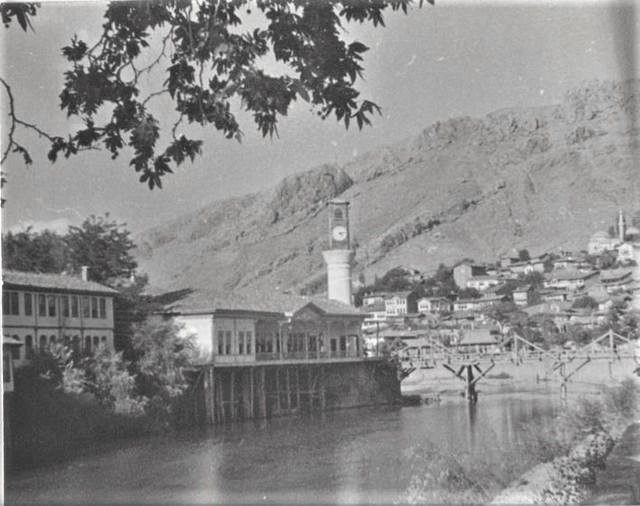
The tower you see today was built in 2002.
The original was pulled down in 1940 — with the promise of
building a better one. For sixty-two years nothing was put in its place.
1864–1866Ziya PaşaRebuilt in 2002
1937 — the original tower, three years before it was pulled down. On the rock,
in a spot visible from everywhere in the city.1 On the right, the timber
Helkıs Bridge.
Look at the foot of the tower: there is no distinct base — the shaft rises
straight from the ground.1Hüseyin Menç Archive.
📜 What do the documents say?
The tower stands within the city's Helkıs neighbourhood, in front of the
Hükümet (Government) Bridge.
It was designed on the rock that separates Bağ Helkıs from Sade Helkıs, in
a commanding position visible from everywhere in the city.1
It was built as part of the extensive building works carried out in
1864-1866 by Ziya Paşa, governor (mutasarrıf) of Amasya. As part
of those works, six clock towers in all were built — in the town and in its five
districts.2
The tower was damaged in a fire in 1865 and restored again, staying true
to the original.3
Pulled down, then rebuilt
1864–66
Ziya Paşa has the tower built; one of six towers.2
1865
Fire. The tower is damaged and restored, staying true to the
original.3
1940
The governor of Amasya at the time, Talat Öncel, has it pulled down
completely, with the promise of “building a better one”.1
The Governorship's city guide gives a different reason: the tower was pulled
down because it had been damaged during the building of the new
bridge.4
1940–2002
For many years no new tower could be built in its place.1
2002
Led by Governor Hüseyin Poroy, the present tower is rebuilt true to
the original on the spot where the old tower stood.1
The same Governor Talat Öncel had also changed another building on this route: the
Helkıs Bridgewas rebuilt by him in reinforced concrete
in 1940. So in the same year, in the same view, two buildings changed at
once.
1919: the flag on top of the tower
According to the Governorship's city guide, this tower has, besides telling the
time, a special meaning for the people of Amasya.4 That meaning
comes from a day on which the documents and the folk narrative stand side by side.
📜 What do the documents say?
In 1919, in the days of the occupation, the Turkish flag on the clock tower
in Amasya was taken down and the British flag raised; this provoked a
reaction among the people.5
The document says this much. The city itself tells the rest.
🗣️ What do the people say?
The guide gives the event as a story told from generation to generation
like a parable: British soldiers break down the door of the tower, take down
the Turkish flag and raise their own in its place. As the crowd gathered in the
square is on the brink of revolt, the mufti Hacı Tevfik Efendi, the kadı Ali
Himmet Efendi, Hoca Bahaeddin Efendi and the preacher
Abdurrahman Kâmil Efendi calm the people. Unable to
hold back his tears, the kadı Ali Himmet Efendi cries out: God is great; in
the homeland of a noble nation like ours, a foreign flag cannot wave. At that
moment a roar rises; a short storm that breaks out of nowhere tears the
British flag on top of the tower to pieces and flings it over the
Yeşilırmak. The people raise the Turkish flag that had been taken down back
in its place, with the besmele and cries of tekbir.4
Read the original Turkish
“Allah büyüktür, bizim gibi asil bir milletin memleketinde yabancı bayrağı
dalgalanamaz.”
That the flag was taken down and raised is in the documents; the storm is the
parable itself. This page neither confirms nor belittles it — it shows how a
city remembers that day.
👁️ What did the witnesses see?
The memoirs of Osman Fevzi Olcay. At the foot of the tower there was
once a coffee house. Olcay's friend Yeloğlu Hafız Efendi spent most of his time
there, playing cards with Gök Ömeroğlu Mustafa Ağa, a sergeant of the mounted
gendarmerie. According to Olcay the sergeant would resort to every kind of
trick to beat Hafız Efendi; and a good many of the coffee house's customers
came to watch these two champions.6
The foot of the tower has never stood empty: today there is a shop in its base,
and once there was a coffee house at its foot. Olcay's words are our
translation.
“True to the original” — but not quite
In old photographs no distinct base can be seen on the tower.
Yet during its construction in 2002, a square base of dressed stone,
about 2.5 metres high, was added to the tower, and a shop belonging to a
private business was placed inside this part.1
~2.5 mHeight of the base added in 2002.
SquareThe plan of the base; dressed stone.
1 shopPlaced inside the base.
62 yearsBetween demolition and rebuilding.
You can check this with your own eyes. In the 1937 photograph above, the shaft
of the tower rises straight from the ground. When you see it today, there is a
mass of stone beneath it — and a shop at work inside.
This page does not judge this as a fault. It simply says: “true to the
original” does not always mean “identical to the original” — and
the way to see the difference is to look at old photographs.
Look at the foot of the tower
First look at the 1937 picture above: the shaft comes straight out of the
rock and ground; there is no mass of stone beneath it.1
Then raise your head and look at today's tower. Find the square
dressed-stone base, about 2.5 metres high, beneath it.1
There is a shop inside.
The difference between the two pictures is sixty-two years.
In between, there was no tower in this view. And remember this too: Ziya Paşa had
six towers built — one for the town, five for the districts.2
This is one of those six.
While you are there, look for
The stone of the base. Added in 2002.1
The rock the tower stands on. The rock that separates Bağ Helkıs from Sade
Helkıs.1
Look out over the city. The spot was chosen so that the tower could be
seen from everywhere in the city.1
The Hükümet Bridge in front of it.
Both passed through the hands of the same governor in 1940.1
The clock. This was the tower's real job: to give the city a shared
time.
Key facts
Original
1864–1866, Mutasarrıf Ziya Paşa2
Present structure
2002, led by Governor Hüseyin Poroy1
Demolished
1940, Governor Talat Öncel1
Location
Helkıs neighbourhood; in front of the Hükümet Bridge, on the rock separating Bağ Helkıs from Sade Helkıs1
Added in 2002
~2.5 m square base of dressed stone; a shop inside1
Its siblings
In the same building programme: the town + five districts = six towers2
Coordinates
40.65284918, 35.83340627 — verified from an external source
In the book
Kültürel Miras Boyutuyla Amasya
This building is not recorded in OpenStreetMap; its coordinates were verified
from Kültür Envanteri and Wikidata records.
The Hükümet Bridge is at 40.652705, 35.833525 in OSM — the tower stands in
front of it.1
Every factual statement on this page rests on one of the sources below.
Titles are given in their original Turkish so that they can be found;
quotations from them are our translations.
Emre Kolay, Amasya İl Merkezinde Geç Dönem Kamu Yapıları (1848-1947) (Samsun: Ondokuz Mayıs Üniversitesi Sosyal Bilimler Enstitüsü, Yüksek Lisans Tezi, 2013), 20, 35-36.
Kenan Akyüz, Ziya Paşa'nın Amasya Mutasarrıflığı Sırasındaki Olaylar (Ankara: Ankara Üniversitesi Basımevi, 1964), 3.
Arife Koca, Kent Mimarisinde Değişen Sınır Kavramı: Amasya Örneği Üzerinden Bir İnceleme (Eskişehir: Anadolu Üniversitesi Fen Bilimleri Enstitüsü, Yüksek Lisans Tezi, 2019), 73.
Amasya Valiliği, Amasya Şehir Rehberi (Amasya: Amasya Valiliği, 2013), 94-95. — The section “Saat Kulesi”: the reason for the demolition of 1940, and the tower's “story told from generation to generation like a parable”.
Orhan Özger, Milli Mücadele Döneminde Amasya Müftüsü Abdurrahman Kamil Efendi (Edirne: Trakya Üniversitesi Sosyal Bilimler Enstitüsü, Yüksek Lisans Tezi, 2023), 82-83.
Osman Fevzi Olcay, Amasya Hatıraları (Bildiklerim, Gördüklerim, İşittiklerim) (Amasya: Amasya Belediyesi, 2009), 94-95. — “Hafız Efendi (Yeloğlu)”.