Adım Adım Amasya

The Princes' Route · Stop 10

Madenüs Bridge

Directly opposite the first stop of the route. Its roots reach back to a city gate of Roman times — but the bridge you see today was built in 2010.

Roman in origin Yeşilırmak 2010 reinforced concrete
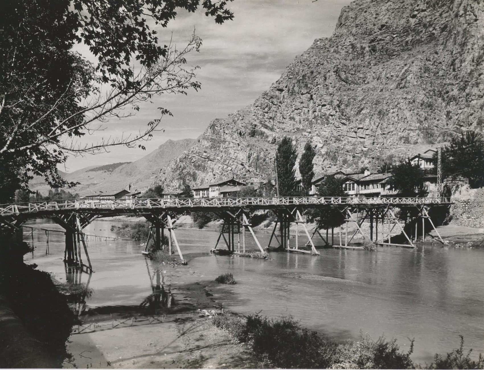
The Madenüs (Maydanoz) Bridge, 1955
The Madenüs Bridge, 1955 — its timber form, before it was pulled down. Sıtkı Karadağ Archive.

In the sources and in popular speech

Mağdinus · Magdenos · Madenüs → “Maydanoz”

The people turned a name that was hard to pronounce into their own language: maydanoz means ‘parsley’.1 Today many in Amasya know this bridge as the Maydanoz Bridge.

📜 What do the documents say?

The bridge stands in front of the Sultan Bayezid II Complex, level with the madrasa. In the sources it appears as the “Mağdinus” or “Magdenos” Bridge, or in popular speech as the “Maydanoz” Bridge.1

The bridge is thought to have been connected with the Meydan Gate, one of the gates leading out of the walled city in the Roman period, and to have formed part of a commercial axis.2

Why was it always being rebuilt? Built mostly of timber over the course of history, the bridge was one of the structures most vulnerable to the floods of the Yeşilırmak.1 This stop is as much the story of a struggle with a river as the story of a bridge.

👁️ What did the witnesses see?

1645 · Evliya Çelebi. Listing the gates of the lower castle by the river, Evliya uses a familiar name: The Maydanoz Gate is the way to the Bridge of Bayezid Han. By this road one goes towards Merzifon, Gelgiras and Ladik. So the name “Maydanoz” was already in use in 1645.3

The sources do not say clearly whether the bridge Evliya calls the “Bridge of Bayezid Han” is today's Madenüs Bridge. The list accompanying Albert Gabriel's city plan of 1928 includes, besides the wooden “Maydanoz (Madenüz) bridge”, a separate ruined “Sultan's bridge” whose foundations lie under the river. Evliya, for his part, writes that the Meydan Gate faced the Great Wooden Bridge leading to the Gök Medrese.3 The question is open; this page does not invent an answer.

The same crossing, three bridges

The place did not change; the bridge changed three times.4

While you are there, look for

Key facts

Origin
Connected with the Meydan Gate of the Roman period2
Names
Mağdinus · Magdenos · Madenüs · popularly “Maydanoz”1
Position
In front of the Bayezid II Complex, level with the madrasa1
Present bridge
2010, reinforced concrete4
Earlier
Timber until 1968; then an iron footbridge on concrete piers4
Location
40.651408, 35.826138 — verified against OpenStreetMap
In the book
Kültürel Miras Boyutuyla Amasya, p. 60

📍 Open on the map 🚶 Walking route (Google) 🚶 Walking route (Yandex)

Sources

Every factual statement on this page rests on one of the sources below. Titles are given in their original Turkish so that they can be found; quotations from them are our translations.

  1. Gediz Urak, Amasya'nın Türk Devri Şehir Dokusu ve Yapılarının Analiz ve Değerlendirilmesi (Ankara: Gazi Üniversitesi Fen Bilimleri Enstitüsü, Doktora Tezi, 1994), 504.
  2. Kani Kuzucular, Amasya Kenti'nin Fiziksel Yapısının Tarihsel Gelişimi (İstanbul: İstanbul Teknik Üniversitesi Fen Bilimleri Enstitüsü, Doktora Tezi, 1994), 30.
  3. Ali Tuzcu, Seyahatnâmelerde Amasya (Amasya: Amasya Belediyesi Kültür Yayınları, 2007), 67, 355. — Evliya Çelebi's account of the gates of the lower castle (67); the list of monuments and bridges belonging to Albert Gabriel's city plan of 1928 (355).
  4. Amasya Harşena Dağı ve Pontus Kral Kaya Mezarları Alan Yönetim Planı ve UNESCO Dünya Mirası Başvuru Dosyası (Amasya: Amasya Belediyesi, 2022), 62.
  5. “Amasya”, Türkiye İl İl: Dünü, Bugünü, Yarını — Yurt Ansiklopedisi, C. 1 (İstanbul: Anadolu Yayıncılık, 1982), 411. — “Amasya'da Su Taşkınları” (floods in Amasya): “In 1968 the Yeşilırmak rose and caused great damage in the town. The Maydanoz Bridge was also destroyed at this time.”

Continue the route

The Princes' Route · stop 10 of 14

Water and Healing · stop 9 of 11